GPS Navigation
After a little thought, I decided the best way to start my new blog was to mention a recent addition that dramatically changed my traveling experience.
Before heading out on my road trip to Alaska, a friend named Mike decided to buy me a GPS system to help me get around in unfamiliar territory. Prior to this Mike had bought his Czech wife a small GPS system that she could use to find her way back home. Evidently, this was a huge success. As a result, Mike concluded that such an item would be immensely useful to me, considering the places I go and type of work that I do.
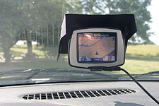
So we marched down to the nearest electronics store and purchased a Garmin StreetPilot 330c. As with all new technologies, I was initially disoriented by the device. It did not take long, however, to figure it out and become acquainted with its various functions.
So, off I went on my trip. The first leg took me to Traverse City, MI. This was a familiar route that I had taken before and served as a good test of the little StreetPilot. The unit did an exemplary job of keeping track of where I was and where I should be turning. It took me right up the same path I had taken before.
Along the coast of Lake Michigan, the GPS system began to yeild a few surprising advantages. As travelers know, many stretches of Interstate are bracketed by a wall of tall trees, designed to keep you from seeing the landscape on the other side. As a result, you have no idea what's over there. The StreetPilot, with its overhead point of view, showed me exactly what was out of my visual range.
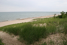
To the left was both the Lake Michigan shoreline, and a parallel frontage road. Knowing this was now there, I took an exit and drove along the frontage road for a number of miles. This route was much more scenic and interesting than the Interstate. Without the StreetPilot, I would never have known it was there. And when it came time to get back on the Interstate, my helpful electronic assistant knew exactly what to do.
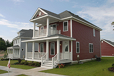
Reaching Traverse City, the GPS unit took me precisely to the address I had requested. At this point I need to explain how I go about my work. Typically, I will meet with a home builder and someone from his office will either take me to a subdivision or point it out on a map. I then have to return several times to that location to complete my photographic assignment. The StreetPilot came in very handy, because once I knew where a model home was, I could pinpoint it in the system and have the unit plot a route back to it from wherever I happened to be. This allowed me to roam about and never worry about having to remember how to get somewhere. Before long, I discovered that I had become totally dependent on this intelligent machine.
The next advantage the StreetPilot produced was to allow me to explore the countryside without fear of getting lost. I love to explore back roads and take pictures of interesting subjects that are off the beaten trail. When doing this in the past, I always had to be cautious and keep track of my current position. This time, the situation was different. Not only did my GPS unit always know where I was, but it could take me back to any location as soon as I decided to quit fiddling around. This opened up a whole new world to me.
The next leg of my trip would be a big test for the system. I needed to get to Minneapolis and this meant going through Michigan's Upper Peninsula, a region I had never been to before. Prior to leaving, I had gone to MapQuest and had printed out detailed maps of my entire journey. For the last three years I have been doing this and MapQuest has been always reliable. Over the course of my trek to Minnesota, I was going to compare the differences in recommended routes between the Garmin unit and the MapQuest system.
Driving along, there were some variations in the routes that had been selected. I decided to go with the Garmin route and it turned out to be just fine. Again, I followed directions and wound up driving right to the doorstep of my good friends in Minneapolis.

Here, I would like to point out a minor flaw in the Garmin system. I attribute this to having out-of-date maps. A few times along the way, new construction had obviously taken place and the information in my system didn't jive with what I was encountering. Under these conditions, the unit would attempt to send me down a path that no longer existed. Once I passed the anomaly, however, my StreetPilot latched right back on to the old roads it recognized and we kept going. I assume that fresh maps can be uploaded that are newer than those in units that have been setting on the shelves for some time. This is one reason I still keep MapQuest in reserve for special situations. Being a public service, I suspect it keeps its information reasonably up to date.
Finally the time came to make the big leap and enter a foreign country, Canada. This would be my first time traveling outside the bounds of the United States. The prospect of being in a strange new land made me a little anxious. Fortunately by this point I had become relatively comfortable with the digital navigator and was glad to have it as a backup.

I spent six days driving from Minneapolis to Palmer, Alaska. I saw some breathtaking scenery and was relaxed enough to enjoy it due to the confidence I had in the Garmin navigator. Again, I was always comforted by the fact that the system knew my exact position and could tell me lots of information about what was ahead. At any moment, the device could tell me how far away I was from any particular point and how long it would take for me to get there. Very reassuring, to say the least.
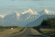
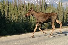
The other thing the StreetPilot did was to allow me to concentrate on potential road hazards. In upper British Columbia and the Yukon Territories, there is quite a bit of wildlife on the highways. Hitting a moose or a horse or a bighorn sheep could be disasterous. One of these could be around any corner. Sometimes I would find a wild animal standing right in the middle of the road. With the StreetPilot in operation, there was no need to glance at a map or be on the lookout for a particular turn. This freed my mind so I could focus on driving conditions.
Reaching Alaska, I had discovered many of the StreetPilot's features and was ready to make good use of them. Again, the unit helped keep track of my photographic subjects and freed me to explore the wilderness. It was this way over the whole rest of the 33-day trip.
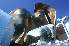
On my way back from Alaska, I had to visit Carson City, NV to complete a third and finally assignment. My path there took me through Seattle, where I stopped and enjoyed a couple of days with an old friend named Gary. During my visit, he and I went downtown so that I could take some shots of the buildings and check out a few tourist attractions. Gary, being a helpful individual, always suggested a route to take. He was a bit deflated when I showed him how well the StreetPilot worked. We used it to find the Pike Place Market and the Experience Music pavillion.
I believe my drive from Seattle to Carson City was the longest one-day drive I have made to date, over 700 miles. Again, my electronic navigator got me there with ease. It did take me down a few back roads that passed through heavily forested areas, but I had confidence that the Garmin unit was taking me down the most preferential path.
Once in Carson City, the StreetPilot gave me the opportunity to roam the little twisted roads of the Nevada desert. It was loads of fun. It also helped me make my way around awesome Lake Tahoe. Completing my assignment there, the StreetPilot led me to, and through, the Salt Lake region, Arches National Park, and central Colorado. By the time I reached home, I was fairly adept in the use of this fantastic helpmate.

Since my recent trip to Alaska, I have returned to Minneapolis, where I completed another photographic assignment for a local home builder there. During my stay, I compared notes with another individual who owned a slightly more advanced version of the StreetPilot. He, too, was extremely happy with his purchase.
Before heading out on my road trip to Alaska, a friend named Mike decided to buy me a GPS system to help me get around in unfamiliar territory. Prior to this Mike had bought his Czech wife a small GPS system that she could use to find her way back home. Evidently, this was a huge success. As a result, Mike concluded that such an item would be immensely useful to me, considering the places I go and type of work that I do.
So we marched down to the nearest electronics store and purchased a Garmin StreetPilot 330c. As with all new technologies, I was initially disoriented by the device. It did not take long, however, to figure it out and become acquainted with its various functions.
So, off I went on my trip. The first leg took me to Traverse City, MI. This was a familiar route that I had taken before and served as a good test of the little StreetPilot. The unit did an exemplary job of keeping track of where I was and where I should be turning. It took me right up the same path I had taken before.
Along the coast of Lake Michigan, the GPS system began to yeild a few surprising advantages. As travelers know, many stretches of Interstate are bracketed by a wall of tall trees, designed to keep you from seeing the landscape on the other side. As a result, you have no idea what's over there. The StreetPilot, with its overhead point of view, showed me exactly what was out of my visual range.
To the left was both the Lake Michigan shoreline, and a parallel frontage road. Knowing this was now there, I took an exit and drove along the frontage road for a number of miles. This route was much more scenic and interesting than the Interstate. Without the StreetPilot, I would never have known it was there. And when it came time to get back on the Interstate, my helpful electronic assistant knew exactly what to do.
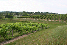
Reaching Traverse City, the GPS unit took me precisely to the address I had requested. At this point I need to explain how I go about my work. Typically, I will meet with a home builder and someone from his office will either take me to a subdivision or point it out on a map. I then have to return several times to that location to complete my photographic assignment. The StreetPilot came in very handy, because once I knew where a model home was, I could pinpoint it in the system and have the unit plot a route back to it from wherever I happened to be. This allowed me to roam about and never worry about having to remember how to get somewhere. Before long, I discovered that I had become totally dependent on this intelligent machine.
The next advantage the StreetPilot produced was to allow me to explore the countryside without fear of getting lost. I love to explore back roads and take pictures of interesting subjects that are off the beaten trail. When doing this in the past, I always had to be cautious and keep track of my current position. This time, the situation was different. Not only did my GPS unit always know where I was, but it could take me back to any location as soon as I decided to quit fiddling around. This opened up a whole new world to me.
The next leg of my trip would be a big test for the system. I needed to get to Minneapolis and this meant going through Michigan's Upper Peninsula, a region I had never been to before. Prior to leaving, I had gone to MapQuest and had printed out detailed maps of my entire journey. For the last three years I have been doing this and MapQuest has been always reliable. Over the course of my trek to Minnesota, I was going to compare the differences in recommended routes between the Garmin unit and the MapQuest system.
Driving along, there were some variations in the routes that had been selected. I decided to go with the Garmin route and it turned out to be just fine. Again, I followed directions and wound up driving right to the doorstep of my good friends in Minneapolis.
Here, I would like to point out a minor flaw in the Garmin system. I attribute this to having out-of-date maps. A few times along the way, new construction had obviously taken place and the information in my system didn't jive with what I was encountering. Under these conditions, the unit would attempt to send me down a path that no longer existed. Once I passed the anomaly, however, my StreetPilot latched right back on to the old roads it recognized and we kept going. I assume that fresh maps can be uploaded that are newer than those in units that have been setting on the shelves for some time. This is one reason I still keep MapQuest in reserve for special situations. Being a public service, I suspect it keeps its information reasonably up to date.
Finally the time came to make the big leap and enter a foreign country, Canada. This would be my first time traveling outside the bounds of the United States. The prospect of being in a strange new land made me a little anxious. Fortunately by this point I had become relatively comfortable with the digital navigator and was glad to have it as a backup.
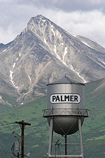
I spent six days driving from Minneapolis to Palmer, Alaska. I saw some breathtaking scenery and was relaxed enough to enjoy it due to the confidence I had in the Garmin navigator. Again, I was always comforted by the fact that the system knew my exact position and could tell me lots of information about what was ahead. At any moment, the device could tell me how far away I was from any particular point and how long it would take for me to get there. Very reassuring, to say the least.
The other thing the StreetPilot did was to allow me to concentrate on potential road hazards. In upper British Columbia and the Yukon Territories, there is quite a bit of wildlife on the highways. Hitting a moose or a horse or a bighorn sheep could be disasterous. One of these could be around any corner. Sometimes I would find a wild animal standing right in the middle of the road. With the StreetPilot in operation, there was no need to glance at a map or be on the lookout for a particular turn. This freed my mind so I could focus on driving conditions.
Reaching Alaska, I had discovered many of the StreetPilot's features and was ready to make good use of them. Again, the unit helped keep track of my photographic subjects and freed me to explore the wilderness. It was this way over the whole rest of the 33-day trip.
On my way back from Alaska, I had to visit Carson City, NV to complete a third and finally assignment. My path there took me through Seattle, where I stopped and enjoyed a couple of days with an old friend named Gary. During my visit, he and I went downtown so that I could take some shots of the buildings and check out a few tourist attractions. Gary, being a helpful individual, always suggested a route to take. He was a bit deflated when I showed him how well the StreetPilot worked. We used it to find the Pike Place Market and the Experience Music pavillion.
I believe my drive from Seattle to Carson City was the longest one-day drive I have made to date, over 700 miles. Again, my electronic navigator got me there with ease. It did take me down a few back roads that passed through heavily forested areas, but I had confidence that the Garmin unit was taking me down the most preferential path.
Once in Carson City, the StreetPilot gave me the opportunity to roam the little twisted roads of the Nevada desert. It was loads of fun. It also helped me make my way around awesome Lake Tahoe. Completing my assignment there, the StreetPilot led me to, and through, the Salt Lake region, Arches National Park, and central Colorado. By the time I reached home, I was fairly adept in the use of this fantastic helpmate.
Since my recent trip to Alaska, I have returned to Minneapolis, where I completed another photographic assignment for a local home builder there. During my stay, I compared notes with another individual who owned a slightly more advanced version of the StreetPilot. He, too, was extremely happy with his purchase.
posted by Tom Palmer at 7:42 PM
![]()
![]()


0 Comments:
Post a Comment
<< Home