Driving To Alaska - part 2
Now that I have covered some of the logistical aspects of driving to Alaska, I will tell you what I saw.
I began by driving North up Highway 75 towards Winnepeg. Skirting Winnepeg, I briefly took Highway 1 West, until I connected with Highway 16, the so-called "Yellowhead Highway".
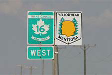
For several days I traversed the Yellowhead Highway, taking it from Winnipeg, Manitoba, through Saskatchewan, to Edmonton, Alberta. On either side of this route was farmland, punctuated by a repeating series of grain elevators. Not much else. If I didn't know better, I would have sworn I was in Iowa or Nebraska. Of course, I was traveling right over Nebraska, so the landscape looked the same. This took me back a little because I thought things might look a bit different in a foreign country. They didn't. This was part of coming to terms with my misconceptions.
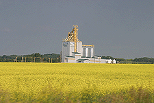
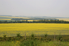
Now, the flip side of my damaged expectations was that I expected the farmers to be growing corn and soybeans and wheat . They weren't. They were growing canola. Vast stretches of lower Canadian farmland were colored a bright dazzling yellow. I didn't know what this was at first, and it certainly was eerie. Later, after seeing a billboard and having talked to a filling station attendant, did I learn what this omnipresent crop was.
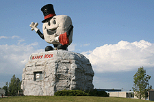
All rural landscapes are dotted with tiny farming communities, and Canada was no exception. The amusing thing was that many of these towns had an iconic mascot. In Gladstone, I was greeted by "Happy Rock", a smiling nugget who was affectionately waving. At Beaver Lodge, there was a giant concrete beaver. Following that, there were oversized ducks and bears and lumber jacks. It really showed you how laid back and fun-loving Canadian citizens are. In fact, every person I encountered in Canada was exceedingly nice, friendly and helpful. A great lot, they were.
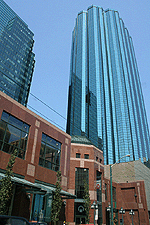
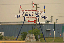
Reaching Edmonton, I stopped for a few moments to inspect a major Canadian city. It seemed to be very modern and culturally complex. Evidently, in places, Canada is very sophisticated. Well, how can anyone not know that? Moving along, I turned North, up Highway 43, until I reached Dawson Creek, British Columbia the official starting point of the famous "Alaska Highway".
In Dawson Creek, there is a prominent sign stating that you are at "Mile 0" on the Alaska Highway. I found it interesting that even though Canada uses the metric system, landmarks along the Alaska Highway are called out in miles.
Anyway, I set out on this 1390-mile long, two lane road and immediately started to notice changes in the scenery. The flat crop-laden fields along the Yellowhead Highway had transformed into rolling hills, covered with evergreens. Their piney scent permeated the air. Also in the air was smoke from a number of nearby forest fires. This gave the atmosphere a distinct yellow cast and was quite unnerving to drive through over a long period of time. In some areas, the fog was dense enough to obscure the horizon. I was told later, that several nearby towns had been forced to evacuate.

Over time, British Columbia grew more mountainous, which caused the roads to become increasingly angular and twisted. One particular stretch, between Summit Lake and Muncho Lake, yielded an abundance of wildlife. Prior to this, signs were beginning to appear warning drivers to be on the lookout for moose and sheep. It wasn't very long before these predictions came true. Rounding a curve, a family of bighorn sheep appeared before me, three males, two females and a baby. A couple of cars had pulled off the side of the road and were quietly observing them. I joined the fascinated onlookers for a couple of moments.

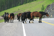
North of Muncho Lake, where I camped for the night, were new signs alerting the presence of wild horses and buffalo. Sure enough, several miles beyond, were packs of animals casually wandering down one lane of the highway, with automobiles creeping along behind. Like the sheep, the buffalo were shaggy in appearance, abandoning their thick Winter coats. The thing that made the horses stand out were their exaggerated muscularity.
And then there were the bears. Over the course of my trek, I saw three young bears along the road. Before leaving on my assignment, almost everyone advised me to be on my guard for these furry creatures. I certainly tried to put myself in a position where I would never encounter one. While looking over a potential campsite one evening, I noticed a large sign detailing what a person should do if they were to come face-to-face with a wild bear. It was divided into 7 sections, each devoted to a specific type of bear situation. That was being more prepared that I cared to be, so I went to a more populated campsite and surrounded myself with a protective layer of other campers, which a hungry bear might choose to eat first.

The animals that did manage to eat me alive were mosquitoes. God, they were awful. The minute you went near the grass they would swarm. It wasn't long before I learned to cover as much of my body as possible with clothing and then spray the exposed skin with repellant. Folks had commented on the mosquito problem early on, saying they were worst in Alaska. Alaska, wasn't bad, however. The true culprits were British Columbia and the Yukon. I fantasized about the mosquito being one of these Province's official bird. That was until other travelers started repeating the idea back to me.
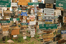
At the edge of the Yukon border I was surprised by an unanticipated treat. Watson Lake, a milepost community, contained an oddly unique, yet well-know attraction, called the "Signpost Forest". This was an area about half the size of a city block, containing hundreds of tall, upright posts. Nailed to every pole were about a dozen signs, each displaying the name of a city or family. Starting with a single individual, this phenomenon has grown continually over the years, reaching epic proportions. People now come from all over the world, just to leave their mark at this famous crossroads.
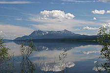
Building on British Columbia's natural beauty, the Yukon Territories were ever more picturesque. I especially enjoyed the drive along a large body of water known as Kluane Lake and an inlet named Destruction Bay, with its aquamarine waters. On the opposite side of the highway was Kluane National Park and Perserve, which flaunted several rugged, snow-capped mountain tops. This was just a taste of what was to come.
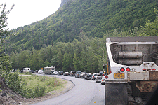
It was on this stretch of the Alaska Highway that reports of weather-related road damage came true. Yes, the closer to Alaska one got, the more wavy and distressed the roads became. It was a bit of a rollercoaster ride in places, causing traffic to slow down considerably. What was more distressing, though, were the intermittant sections of roads that were being repaved. On at least five occasions, I sat in a long line of vehicles waiting to go down a single lane of the thoroughfare.
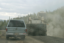
Frequently, sections of road which were under rehab had been reduced to gravel, perhaps 1 to 5 miles at a whack. Fortunately the pace car leading us never exceeded 30 mph, so no damage was done. Afterward, you would find yourself whizzing down a perfectly smooth, newly paved section of road. That part was great.
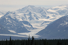
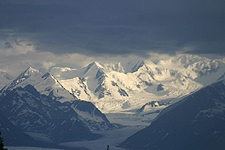
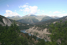
But the greatest part was the Alaska scenery. It was simply breath-taking. British Columbia and the Yukon had served merely as a prelude to Alaska's heavenly majesty. The mountain ranges, glaciers and dramatic weather produced an awesome sight. Thank goodness that road planners had seen fit to place turnoffs along the highway at frequent intervals. I stopped to take advantage of a number of these.
To visit Palmer, AK, my end destination, I departed the Alaska Highway near Tetlin Junction. My new route was Highway 1, also known as the Tok Cutoff. This took me past some remarkable scenery, including the Matanuska Glacier, which I will mention in a future entry.

Both entering and leaving Alaska were an easy proposition. I barely remember doing either. Returning to America had some distinct advantages. First you have to realize that there is basically only one road into or out of Alaska. So if you are returning the same way you came in, you are forced to see everything twice. What a fantastic opportunity. On my way back home, I was not quite in such a hurry and this allowed me to savor many of the landmarks I had rushed by before.
Eventually, I made my way back to Mile 0 of the Alaska Highway at Dawson Creek, where I took a new path that would lead me to Seattle. This route, primarily Highway 97, finished taking me from one end of British Columbia to the other. As I drove South, I noticed several distinct geographic regions. In central British Columbia, the land was red and covered with sagebrush. Like Nevada, it's terrain was smoother, with gently rolling hills. Lower BC resembled Colorado. There were moderately high peaks above the road and roaring, winding rivers below. The highway snaked its way along the edge of all this in the middle.
After 15 days of driving in and around Canada and Alaska, I re-entered the United States at Sumas, Washington. My eagerly-waiting friend, Gary told me there might be a multi-hour wait to cross the border. Yes, there was indeed a long line, but I think I made it to the gate in just under 60 minutes. Once there, I had no difficulties in crossing the border. Several vehicles with Canadian license plates were not quite so lucky.
I began by driving North up Highway 75 towards Winnepeg. Skirting Winnepeg, I briefly took Highway 1 West, until I connected with Highway 16, the so-called "Yellowhead Highway".
For several days I traversed the Yellowhead Highway, taking it from Winnipeg, Manitoba, through Saskatchewan, to Edmonton, Alberta. On either side of this route was farmland, punctuated by a repeating series of grain elevators. Not much else. If I didn't know better, I would have sworn I was in Iowa or Nebraska. Of course, I was traveling right over Nebraska, so the landscape looked the same. This took me back a little because I thought things might look a bit different in a foreign country. They didn't. This was part of coming to terms with my misconceptions.
Now, the flip side of my damaged expectations was that I expected the farmers to be growing corn and soybeans and wheat . They weren't. They were growing canola. Vast stretches of lower Canadian farmland were colored a bright dazzling yellow. I didn't know what this was at first, and it certainly was eerie. Later, after seeing a billboard and having talked to a filling station attendant, did I learn what this omnipresent crop was.
All rural landscapes are dotted with tiny farming communities, and Canada was no exception. The amusing thing was that many of these towns had an iconic mascot. In Gladstone, I was greeted by "Happy Rock", a smiling nugget who was affectionately waving. At Beaver Lodge, there was a giant concrete beaver. Following that, there were oversized ducks and bears and lumber jacks. It really showed you how laid back and fun-loving Canadian citizens are. In fact, every person I encountered in Canada was exceedingly nice, friendly and helpful. A great lot, they were.
Reaching Edmonton, I stopped for a few moments to inspect a major Canadian city. It seemed to be very modern and culturally complex. Evidently, in places, Canada is very sophisticated. Well, how can anyone not know that? Moving along, I turned North, up Highway 43, until I reached Dawson Creek, British Columbia the official starting point of the famous "Alaska Highway".
In Dawson Creek, there is a prominent sign stating that you are at "Mile 0" on the Alaska Highway. I found it interesting that even though Canada uses the metric system, landmarks along the Alaska Highway are called out in miles.
Anyway, I set out on this 1390-mile long, two lane road and immediately started to notice changes in the scenery. The flat crop-laden fields along the Yellowhead Highway had transformed into rolling hills, covered with evergreens. Their piney scent permeated the air. Also in the air was smoke from a number of nearby forest fires. This gave the atmosphere a distinct yellow cast and was quite unnerving to drive through over a long period of time. In some areas, the fog was dense enough to obscure the horizon. I was told later, that several nearby towns had been forced to evacuate.
Over time, British Columbia grew more mountainous, which caused the roads to become increasingly angular and twisted. One particular stretch, between Summit Lake and Muncho Lake, yielded an abundance of wildlife. Prior to this, signs were beginning to appear warning drivers to be on the lookout for moose and sheep. It wasn't very long before these predictions came true. Rounding a curve, a family of bighorn sheep appeared before me, three males, two females and a baby. A couple of cars had pulled off the side of the road and were quietly observing them. I joined the fascinated onlookers for a couple of moments.
North of Muncho Lake, where I camped for the night, were new signs alerting the presence of wild horses and buffalo. Sure enough, several miles beyond, were packs of animals casually wandering down one lane of the highway, with automobiles creeping along behind. Like the sheep, the buffalo were shaggy in appearance, abandoning their thick Winter coats. The thing that made the horses stand out were their exaggerated muscularity.
And then there were the bears. Over the course of my trek, I saw three young bears along the road. Before leaving on my assignment, almost everyone advised me to be on my guard for these furry creatures. I certainly tried to put myself in a position where I would never encounter one. While looking over a potential campsite one evening, I noticed a large sign detailing what a person should do if they were to come face-to-face with a wild bear. It was divided into 7 sections, each devoted to a specific type of bear situation. That was being more prepared that I cared to be, so I went to a more populated campsite and surrounded myself with a protective layer of other campers, which a hungry bear might choose to eat first.
The animals that did manage to eat me alive were mosquitoes. God, they were awful. The minute you went near the grass they would swarm. It wasn't long before I learned to cover as much of my body as possible with clothing and then spray the exposed skin with repellant. Folks had commented on the mosquito problem early on, saying they were worst in Alaska. Alaska, wasn't bad, however. The true culprits were British Columbia and the Yukon. I fantasized about the mosquito being one of these Province's official bird. That was until other travelers started repeating the idea back to me.
At the edge of the Yukon border I was surprised by an unanticipated treat. Watson Lake, a milepost community, contained an oddly unique, yet well-know attraction, called the "Signpost Forest". This was an area about half the size of a city block, containing hundreds of tall, upright posts. Nailed to every pole were about a dozen signs, each displaying the name of a city or family. Starting with a single individual, this phenomenon has grown continually over the years, reaching epic proportions. People now come from all over the world, just to leave their mark at this famous crossroads.
Building on British Columbia's natural beauty, the Yukon Territories were ever more picturesque. I especially enjoyed the drive along a large body of water known as Kluane Lake and an inlet named Destruction Bay, with its aquamarine waters. On the opposite side of the highway was Kluane National Park and Perserve, which flaunted several rugged, snow-capped mountain tops. This was just a taste of what was to come.
It was on this stretch of the Alaska Highway that reports of weather-related road damage came true. Yes, the closer to Alaska one got, the more wavy and distressed the roads became. It was a bit of a rollercoaster ride in places, causing traffic to slow down considerably. What was more distressing, though, were the intermittant sections of roads that were being repaved. On at least five occasions, I sat in a long line of vehicles waiting to go down a single lane of the thoroughfare.
Frequently, sections of road which were under rehab had been reduced to gravel, perhaps 1 to 5 miles at a whack. Fortunately the pace car leading us never exceeded 30 mph, so no damage was done. Afterward, you would find yourself whizzing down a perfectly smooth, newly paved section of road. That part was great.
But the greatest part was the Alaska scenery. It was simply breath-taking. British Columbia and the Yukon had served merely as a prelude to Alaska's heavenly majesty. The mountain ranges, glaciers and dramatic weather produced an awesome sight. Thank goodness that road planners had seen fit to place turnoffs along the highway at frequent intervals. I stopped to take advantage of a number of these.
To visit Palmer, AK, my end destination, I departed the Alaska Highway near Tetlin Junction. My new route was Highway 1, also known as the Tok Cutoff. This took me past some remarkable scenery, including the Matanuska Glacier, which I will mention in a future entry.
Both entering and leaving Alaska were an easy proposition. I barely remember doing either. Returning to America had some distinct advantages. First you have to realize that there is basically only one road into or out of Alaska. So if you are returning the same way you came in, you are forced to see everything twice. What a fantastic opportunity. On my way back home, I was not quite in such a hurry and this allowed me to savor many of the landmarks I had rushed by before.
Eventually, I made my way back to Mile 0 of the Alaska Highway at Dawson Creek, where I took a new path that would lead me to Seattle. This route, primarily Highway 97, finished taking me from one end of British Columbia to the other. As I drove South, I noticed several distinct geographic regions. In central British Columbia, the land was red and covered with sagebrush. Like Nevada, it's terrain was smoother, with gently rolling hills. Lower BC resembled Colorado. There were moderately high peaks above the road and roaring, winding rivers below. The highway snaked its way along the edge of all this in the middle.
After 15 days of driving in and around Canada and Alaska, I re-entered the United States at Sumas, Washington. My eagerly-waiting friend, Gary told me there might be a multi-hour wait to cross the border. Yes, there was indeed a long line, but I think I made it to the gate in just under 60 minutes. Once there, I had no difficulties in crossing the border. Several vehicles with Canadian license plates were not quite so lucky.
posted by Tom Palmer at 1:20 PM
![]()
![]()


0 Comments:
Post a Comment
<< Home